You are using an out of date browser. It may not display this or other websites correctly.
You should upgrade or use an alternative browser.
You should upgrade or use an alternative browser.
Weather
- Thread starter touchdown
- Start date
dbair1967
Administrator
- Messages
- 69,683
- Reaction score
- 18,049
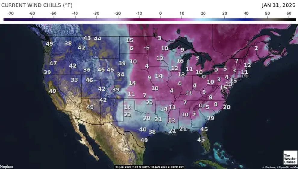
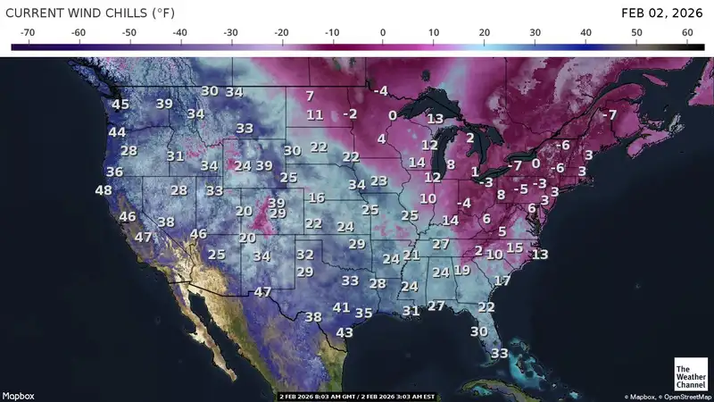
Nobody tell the democrats, but I have ICE in my areaWC is currently 2F.
Doomsday
High Plains Drifter
- Messages
- 27,140
- Reaction score
- 10,823
3 degrees here this morning minus 16 wind chill.WC is currently 2F.
touchdown
Defense Wins Championships
- Messages
- 7,873
- Reaction score
- 7,426
The leftards in the Dallas reddit would freak out if I posted that "Ice was all over Dallas."Nobody tell the democrats, but I have ICE in my area
And they have no sense of humor there either.
They would ban me for such a thread.
touchdown
Defense Wins Championships
- Messages
- 7,873
- Reaction score
- 7,426
What happens when Tesla Full Self-Driving faces snow-covered roads with no visible lane markings? In this video, we take a 2023 Tesla Model X running FSD version 14.2.2.3 out into rare winter conditions in Dallas during “Alaska Day Two.” This drive focuses on how Tesla FSD handles snow and ice, especially when cameras can’t clearly see lane lines, road edges, or pavement texture. The system is tested across Chill, Standard, and Mad Max driving profiles, giving a real-world comparison of speed control, traction management, and comfort in poor conditions.
daboyz
🚀 SCIENTIST
- Messages
- 2,972
- Reaction score
- 3,646
touchdown
Defense Wins Championships
- Messages
- 7,873
- Reaction score
- 7,426
touchdown
Defense Wins Championships
- Messages
- 7,873
- Reaction score
- 7,426
Major nor'easter with blizzard conditions to rage from NYC to Boston and Delaware
A rapidly strengthening storm will bring major travel disruptions to much of the northeastern United States from Sunday to Monday as snow is forecast to pile up with blizzard conditions in coastal areas.
A rapidly strengthening storm will bring major travel disruptions to much of the northeastern United States from Sunday to Monday as snow is forecast to pile up with blizzard conditions in coastal areas.
touchdown
Defense Wins Championships
- Messages
- 7,873
- Reaction score
- 7,426
Rain will expand into the San Francisco Bay Area and northern San Joaquin Valley Tuesday afternoon. “The main spots prone to flooding will be just north of San Francisco Bay in areas of rugged terrain and in the Sierra foothills of Central California,” according to AccuWeather Meteorologist Kai Kerkow.
Wind gusts of 40-50 mph are expected along the Northwest Coast on Sunday, which could result in isolated power outages and downed tree limbs.
Heavy, wet mountain snow expected
Snow levels will be much higher than with the storm last week.
The storm will push the Sierra snow moisture content even closer to the historical average. According to the latest snowpack data, the Northern Sierra remains 12% below the historical average, while the Central and Southern Sierra are 16–21% below average. Even after the monster storm last week, the water content in the snow is still below average simply due to the large gap between winter storms this year.
Snow totaling 5-10 inches will blanket the Cascades into the Siskiyou Mountains this weekend. Avalanche risk will increase above 4,500 feet, particularly where heavy, wet snow accumulates.
Across the Cascades and Siskiyou Mountains above 4,500 feet, 5-10 inches of heavy wet snow is expected this weekend. The storm will shift into the northern Rockies Tuesday into Wednesday, with 8-12 inches of snow expected above 5,500 feet.

 Walking Through Ice Blizzard in Manhattan 2026